The rocks of Ballyroon Mountain were formed from sand, mud and clay at the very end of the Devonian Old Red Sandstone period, ( just before the luxuriant plant growth of the Carboniferous era dramatically changed life on Earth ).
The sand became sandstone in tones of red, blue and grey, the mud finer grey mudstone, and the clay softer blue and green shale. These rocks are known as the Kiltorcan Beds and have revealed the remains of giant sea creatures.
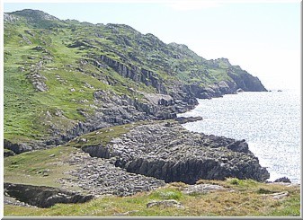
The petrified wave-patterns in the sandstone can easily be seen, and the softer shales have been eroded away forming the ridges and dips which give the immediate landscape its special character.
The horizontal layers of the Kiltorcan Beds were heaved up and thrown onto
their sides by the Armorican uplift, so that the rocks of Ballyroon Mountain
are now layered almost vertically and our farm is a series of dramatic giant
steps down towards the sea.
These earth movements were associated with underground volcanic activity,
and white veins of rock, sometimes containing green copper, can be seen melded
through heat-cracks in the sandstone.
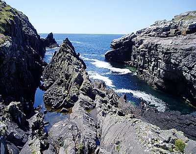
The coast below us is spectacular, with deep gullies, shattered rocks and overhanging cliffs.
The Sheep's Head Way winds its way safely through this complex landscape, but be careful if exploring away from the path.
The various Ice Ages scoured the rocks bare and stripped away the weak areas, you can still see ice-scratched whale-back rocks and huge boulders strewn across the land as if thrown by an Irish giant of long ago. Still reflective lakes have formed in some of the hollows, often invisible until you climb the low summits which hide them. Some are now wet bogs, take care.
Bantry Bay was the path of a huge glacier transporting ice from Ireland's highest mountains to the Atlantic Ocean, which scoured out one of the world's longest and deepest bays. The sea floor below us drops to over thirty fathoms (180ft).
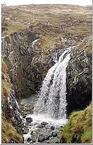
As the climate warmed after the last ice-age (not long ago in geological time) the land here rose a little as the weight of ice was lifted, and our valleys with their small fast streams and rocky cascades are very new. There is a beautiful stepped cascade just below our seaward boundary, the stream then runs in a small deep channel and falls over the rock into a sea pool.
At that time there was a land bridge to Cornwall and Brittany and on to North Spain and Portugal. This resulted in South West Ireland's unique 'Lusitanian' wild plants, some of which you can see on the farm.
The longer-term consequence of warmer climes was, (and still is), a rise in sea level; Bantry Bay, Dunmanus Bay and the other inlets along the coast of West Cork are good examples of such a 'ria' (or drowned valley) coast, and also in numerous islands, such as Bear Island.
Don't be fooled by quiet blue seas in calm weather, this narrow sandstone peninsula is pounded by waves with a force in excess of 20 tons per sq m in heavy winter weather.
Evidence of the sea's force can be seen where fresh rock-scars are revealed and recently-landed boulders can be found 20 feet above high tide level.
At the very end of Sheep's Head, past Tooreen towards the lighthouse, large chunks of rock have collapsed, you are advised to stay clear of the edge.
|
 |
 |
Ballyroon Mountain - Geology